Typhoon Bavi Rocks East Asia
07/08/2026
Samuel Clifford
Super Typhoon Bavi has carved a destructive path across the Western Pacific, unleashing catastrophic winds, torrential rainfall, and widespread damage as it tore through the Northern Mariana Islands. Its most violent strike occurred when the northern eyewall passed directly over the island of Rota, blasting the landscape with hurricane‑force winds well over 150 mph and producing torrential tropical rainfall. Homes have been ripped apart, communications towers are toppled, and trees are stripped bare. Guam, lying just 50 miles to the south, has endured more than 20 inches of rain and wind gusts up to 85 mph. This has triggered flash flooding and power outages across the island.
Guam sits in the heart of “Typhoon Alley,” a region historically battered by intense tropical cyclones. The island’s modern concrete infrastructure exists largely because of historical storms like Typhoon Karen in 1962, which flattened nearly 95 percent of Guam’s buildings with 175‑mph winds. Other infamous storms include Typhoon Pamela in 1976, which raked the island with sustained 140‑mph winds for hours; Typhoon Omar in 1992, which left Guam without power or water for weeks; Super Typhoon Paka in 1997, which recorded a 236‑mph gust before the anemometer failed; and Super Typhoon Pongsona in 2002, which caused more than $700 million in damage. More recently, Typhoon Mawar in 2023 delivered another crushing blow to the island’s infrastructure.
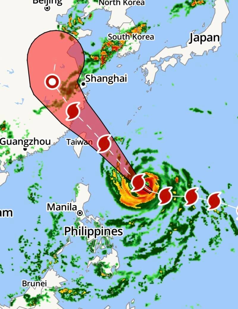
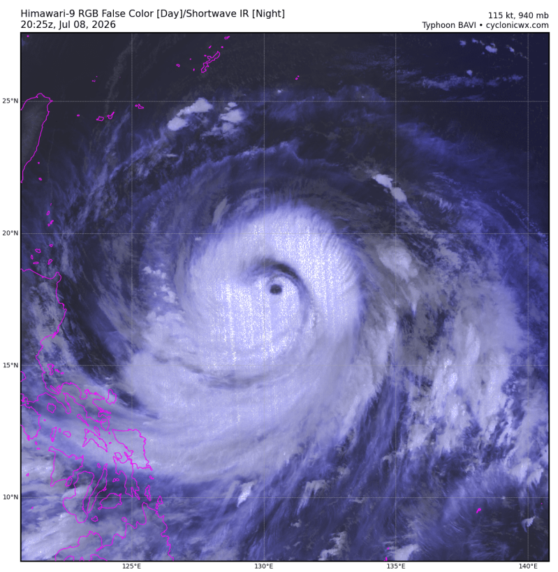
As Bavi moved westward, satellite analysis showed the storm maintaining violent strength and a massive wind field over the Philippine Sea. The storm’s impact extended beyond Rota and Guam. Saipan and Tinian, still recovering from April’s Super Typhoon Sinlaku, which brought sustained winds around 150 mph, gusts up to 185 mph, and more than 20 inches of rain, were forced to brace for another round of damaging winds exceeding 74 mph. Many residents on both islands were still without electricity from Sinlaku when Bavi arrived, compounding the hardship.
The Marianas hold significant strategic importance for the United States. Guam houses Andersen Air Force Base, a critical hub for B‑1, B‑2, and B‑52 bomber rotations, as well as a major U.S. naval installation that serves as homeport to five attack submarines. More than 7,000 active‑duty personnel are stationed on the island. Tinian, meanwhile, is home to North Field, the historic airfield from which the B‑29 bombers that dropped the atomic bombs on Japan departed in World War II. The airfield, once the busiest in the world, is now undergoing renovation as part of U.S. efforts to disperse military assets across the Pacific. As Bavi approached, the U.S. military entered its highest level of storm readiness.
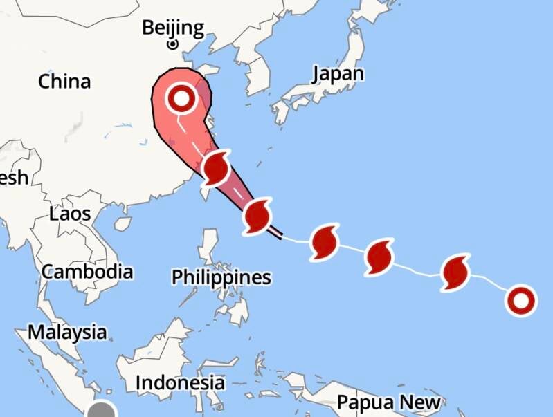
After devastating the Marianas, Bavi turned its sights toward Taiwan. As of Wednesday afternoon, the storm was located about 1,380 kilometers east‑southeast of Cape Eluanbi, moving west‑northwest at 17 to 21 km/h. Taiwan’s Central Weather Administration reported maximum sustained winds of 216 km/h and a storm radius of 380 kilometers. Authorities suspended ferry services to offshore islands, closed tourist attractions, monitored landslide‑prone highways, and prepared traffic restrictions on major bridges. Airlines offered flexible ticket changes, and officials warned that Taipei would enter Bavi’s storm circle by Friday evening, with wind gusts up to 149 km/h and as much as 400 millimeters of rainfall expected.
AccuWeather forecasters warned that Bavi would remain dangerous even if it weakened slightly. Wind gusts up to 160 mph (260 km/h), with a Local StormMax of 200 mph (320 km/h), were anticipated across Taiwan and eastern China. Rainfall totals could reach 18 inches (450 mm), with a Local StormMax of 24 inches (600 mm), leading to flooding, mudslides, structural damage, and major transportation disruptions. Coastal inundation was likely along northern Taiwan and China’s Fujian and Zhejiang coasts. Bavi was rated a 4 on the AccuWeather RealImpact Scale for Tropical Cyclones in Taiwan and eastern China.
Even as cleanup begins in the Marianas, meteorologists are monitoring a developing cluster of thunderstorms between the Federated States of Micronesia and the Marshall Islands. This system may organize into a tropical depression or storm from Friday into early next week, potentially bringing more heavy rain and gusty winds to the already battered islands. Any development could slow recovery efforts following Bavi, though steering patterns may eventually turn the system northeastward, limiting additional land impacts. Residents of Japan are advised to monitor the system as it evolves.
Super Typhoon Bavi’s destructive sweep across the Marianas and its looming threat to Taiwan and eastern China underscore the immense power of Western Pacific cyclones. With recovery still underway from earlier storms and new systems forming behind Bavi, the region faces yet another test of resilience.
Other Recent East Asia Weather:
A violent tornado tore through Hubei province late Monday, leaving a trail of destruction that killed at least 11 people and injured more than 330 as powerful winds ripped apart homes, hurled vehicles through the air, and devastated farmland across central China. One of the most harrowing incidents involved a 30‑year‑old man in Huanggang who was blown out of his 12th‑floor apartment when the twister struck. His furniture was swept out with him, and he remains in intensive care, according to local reports.
Footage circulating online showed the tornado cutting through nearby Ezhou, where five additional deaths were confirmed. State media reported wind speeds near 160 mph, strong enough to shred buildings and lift trucks off the ground. Xinhua described the tornado as a rare EF2, noting that a logistics facility and warehouse in Huanggang were hit especially hard. Several trucks were lifted and thrown as far as 30 meters. In one video posted by Shanghai Daily, people screamed as high winds blew open glass doors on a building’s ground floor, shattering one of them.
Thunderstorms hammered eastern Hubei throughout the night, affecting more than 14,600 residents. Over 330 people were injured, one person remained missing, and more than 20 homes collapsed. Another 4,800 structures suffered varying degrees of damage. Tornadoes are typically seen in southern and coastal provinces such as Guangdong and Jiangsu, making this event highly unusual for Hubei. Meteorological experts told local media that multiple factors, including the remnants of Tropical Storm Maysak, helped trigger the tornado outbreak.
The severe weather extended far beyond Hubei. In southern China’s Guangxi region, record‑breaking rainfall from Maysak caused widespread flooding that killed six people and left 11 missing. More than 375,000 residents were affected, with 130,000 forced to evacuate. Floodwaters also submerged a snake farm, releasing more than 800 snakes, including cobras, into the surrounding area, according to regional officials.
Authorities have deployed thousands of rescuers across the impacted provinces as cleanup and recovery efforts continue. With tornado damage in Hubei, deadly flooding in Guangxi, and landslides triggered by relentless seasonal rains, officials warn that additional storms tied to Maysak’s remnants may continue to pose risks in the days ahead.