Module 2b: Intro to Physical Geology
1/23/2026
Samuel Clifford
Chapter 20: Shorelines
Shoreline- “the line that marks the contact between land and sea. It migrates up and down as the tide rises and falls” (Tarbuck, Lutgens, and Linneman 561).
The restless nature of the ocean is most obvious along the shore, where air, land, and sea meet in a constantly changing boundary called an interface. This coastal zone is where we see tides rising and falling and waves continually rolling in and breaking. It’s a highly active area shaped by the interaction of different parts of Earth’s system.
Even though it may not be immediately noticeable, waves are always reshaping the shoreline. Breaking waves erode the land and move sediment both toward and away from the coast, as well as along it. These processes can create narrow sandbars and delicate offshore islands that often shift in size and shape as storms pass through.
What Causes Ocean Waves?
Ocean waves move along the boundary between the ocean and the atmosphere, carrying energy that can travel thousands of kilometers from distant storms. This is why waves still reach the shore even on calm days. Any time you create ripples—by tossing a pebble into a pond, splashing in a pool, or blowing across a cup of coffee—you’re adding energy to the water, and the waves you see are that energy moving through the liquid.
Most of the energy that shapes coastlines comes from wind‑generated waves. After traveling freely across the ocean, these waves eventually hit the shoreline, which stops their forward motion and forces them to release their energy. In this zone, an almost unstoppable force meets an almost unmoving barrier, creating a constant and sometimes dramatic struggle between land and sea.
Most ocean waves get their energy from the wind. Light breezes create only tiny ripples, but stronger winds generate larger, more organized waves that travel in the same direction as the wind. Wave size depends on wind speed, how long the wind blows, and the fetch—the distance the wind travels across open water.
A wave has crests at the top, troughs at the bottom, and a still‑water level halfway between them. Wave height is the vertical distance from trough to crest, wavelength is the horizontal distance between crests, and the wave period is the time it takes one full wave to pass a point. As more energy is transferred from wind to water, waves grow taller and steeper until they become unstable and break, forming whitecaps.
For any wind speed, there is a limit to how large waves can grow; once this limit is reached, the waves are considered fully developed. When waves move away from the storm that created them or when the wind dies down, they smooth out into long, rolling swells that can travel great distances. Because many wave systems overlap, the sea surface becomes a mix of distant swells and locally generated waves.
20.2
Beach- “an accumulation of sediment found along the landward margin of the ocean or a lake” (Tarbuck, Lutgens, and Linneman 564).
Beaches are made by the sediment around them whether that be from mountains, rivers, cliffs, or even shell fragments. The waves then hurl thousands of tons of water against the land causing erosion. The force causes cracks and crevices to open in cliffs and seawalls. Water is then forced into those cracks and crevices and the air that was in the cracks becomes highly compressed. When the waves subsides the air expands rapidly and that causes rocks to become dislodged. Erosion can also be caused by abrasion. That is when small rock particles impact other rocks via wind, water, or ice.
Sand from the beach moves due to the energy from breaking waves. The level of wave activity determines a net loss or net gain of sand. Low energy waves soaks into the beach and reduces the backwash and therefore causes a movement of sand up the beach face. When the waves are high energy then the beach is much more saturated from the previous waves. Therefore the backwash is strong and a net loss of sand occurs.curs.
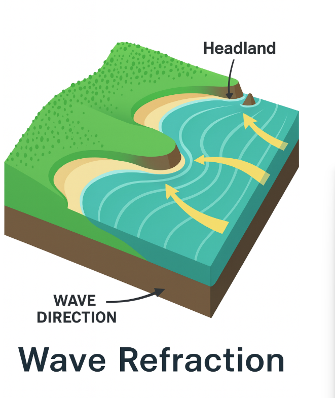
Waves usually approach the shore at an angle, not straight on. As they enter shallow water, the part of the wave closest to shore slows down first, causing the wave to bend and become more parallel to the shoreline. This bending, called wave refraction, focuses wave energy on headlands, leading to more erosion there, while waves spread out and weaken in bays, allowing sand to build up. Over time, this process erodes headlands and fills in bays, gradually straightening the coastline.
Even though wave refraction bends waves toward the shore, they still arrive at a slight angle. This causes the swash—the forward rush of water—to move diagonally up the beach, while the backwash flows straight down. The result is a zigzag motion that shifts sediment along the shore, a process known as beach drift, which typically moves sand and pebbles 5 to 10 meters per day.
Waves striking the shore at an angle generate longshore currents—powerful flows within the surf zone that move parallel to the coast and transport far more sediment than beach drift. These currents carry fine sand in suspension and roll larger particles along the bottom, contributing to massive sediment movement, such as the 750,000 tons per year at Sandy Hook and over 1.5 million tons annually at Oxnard. Together, beach drift and longshore currents create a dynamic system often called a “river of sand,” though unlike rivers, longshore currents can reverse direction seasonally depending on wave approach.
Rip currents, by contrast, are narrow, fast-moving flows that head straight out to sea, opposing incoming waves. While most wave backwash returns as sheet flow along the bottom, some concentrates into surface rip currents, which can be spotted by disrupted wave patterns or suspended sediment. Though they don’t extend far offshore, rip currents pose a danger to swimmers, who should escape by swimming parallel to the shore rather than directly against the current.
20.3
Coastlines display a wide variety of landforms because, although the same basic processes operate everywhere, each coast responds differently depending on factors such as nearby sediment‑rich rivers, tectonic activity, local topography, wind and weather patterns, and the shape of the shoreline. Features carved mainly by wave erosion are called erosional features, while those built by accumulating sediment are depositional features.
Erosional landforms are common along rugged, tectonically active coasts like New England and the U.S. West Coast. Wave‑cut cliffs form as surf erodes the base of coastal rock, causing the cliff to retreat and leaving behind a flat wave‑cut platform. If this platform is later uplifted, it becomes a marine terrace. Wave refraction focuses energy on headlands, carving sea caves, which may enlarge into sea arches; when an arch collapses, it leaves behind an isolated sea stack that will eventually erode away.
Where wave energy decreases, sediment is deposited, creating several distinctive features. A spit is a narrow ridge of sand extending into a bay, often curving landward with the longshore current. If a spit grows completely across a bay, it forms a baymouth bar. A tombolo develops when sand connects an island to the mainland or to another island.
Along the Atlantic and Gulf coasts, broad coastal plains and gentle slopes favor the formation of barrier islands—long, narrow ridges of sand lying a few to several dozen kilometers offshore. These islands, which number nearly 300 from Cape Cod to Texas, often contain dunes 5–10 meters high and shelter quiet lagoons behind them. Over time, lagoons may fill with sediment and become coastal marshes unless strong tidal currents keep them open.
Barrier islands form in several ways: some began as spits cut off from the mainland, others were built by storm waves piling up sand from the seafloor, and some originated as ancient dune ridges formed when sea level was lower during the last glacial period. As sea level rose, these dunes became isolated offshore, creating the barrier‑island systems we see today.
20.4
Emergent coasts form when land rises relative to sea level, often because of tectonic uplift or a drop in global sea level. As the shoreline is elevated, features that once formed at or below the water—such as wave‑cut platforms, sea cliffs, and marine terraces—become exposed on land. These coasts typically have rugged topography, steep slopes, and clearly preserved erosional features that record former shoreline positions.
Submergent coasts develop when sea level rises or the land subsides, allowing the ocean to flood previously dry areas. As valleys and lowlands fill with seawater, features such as estuaries, fjords, and irregular drowned coastlines form. These coasts often contain wide bays, barrier islands, and extensive wetlands, reflecting the way rising water reshapes the landscape by flooding river mouths and low‑lying terrain.
20.5
Whirling tropical cyclones—known as hurricanes in the Atlantic, typhoons in the western Pacific, and cyclones in the Indian Ocean—are Earth’s most powerful storms, sometimes producing winds over 300 kilometers (185 miles) per hour. They function like massive heat engines fueled by the release of heat when warm, moist air rises and water vapor condenses. These storms form mainly between 5° and 20° latitude in late summer and early fall, when sea‑surface temperatures reach at least 27°C (80°F). They rarely form in the South Atlantic or eastern South Pacific because the water there is too cool, and they cannot form within about 5° of the equator because the Coriolis effect is too weak to generate rotation. The Coriolis effect, caused by Earth’s rotation, deflects moving air to the right in the Northern Hemisphere and to the left in the Southern Hemisphere, and this deflection is what allows a storm to spin and organize into a hurricane.
A hurricane is an intense low‑pressure system with a steep pressure gradient that drives strong, spiraling winds toward the center. As warm, moist air flows inward, it rises in a ring of towering cumulonimbus clouds called the eye wall, where the strongest winds and heaviest rainfall occur. At the center lies the eye, a roughly 20‑kilometer‑wide zone of calmer weather where air sinks and warms, creating a deceptively quiet break in the storm. The most destructive hazard is storm surge—a dome of seawater pushed onto land by strong winds and extremely low pressure. Surge is especially severe along shallow continental shelves, such as the Gulf of Mexico, and is always strongest on the right side of the storm’s path in the Northern Hemisphere, where the storm’s forward motion adds to wind speed. Hurricanes also produce destructive winds that can turn debris into dangerous projectiles, damage buildings, and spawn tornadoes. In addition, slow‑moving storms can unleash catastrophic inland flooding, as seen during Hurricane Harvey in 2017, when more than 100 centimeters (40 inches) of rain fell across southeastern Texas. From a geological perspective, hurricanes play a major role in reshaping coastlines by eroding beaches, breaching barrier islands, carving new inlets, and depositing overwash sediments that become part of the long‑term geologic record.
20.6
The shoreline is an extremely dynamic environment, constantly reshaped by waves, tides, storms, and human activity. Powerful storms can erode beaches and cliffs far faster than normal, dramatically altering coastal landscapes and causing major property damage. As coastal development has expanded over the past century—driven by recreation, tourism, and rising property values—the need to protect buildings and infrastructure from erosion has grown as well. This has led to widespread use of hard stabilization, a set of engineered structures designed to control sand movement or shield the coast from wave attack. These include jetties, which are built in pairs at harbor entrances to keep navigation channels open; groins, which extend perpendicular to the beach to trap sand moving along the shore; breakwaters, which create calm water zones for boats; and seawalls, which defend property by reflecting wave energy. Although these structures can solve specific problems, they often create new ones—such as starving downstream beaches of sand, accelerating erosion, or causing sediment to accumulate where it is not wanted. Many coastlines, like those in New Jersey and California, show clear examples of how hard stabilization can unintentionally reshape the shoreline.
Because of these drawbacks, coastal managers increasingly consider alternatives. One widely used method is beach nourishment, which involves adding large quantities of sand to widen beaches and buffer coastal development from storm waves. While nourishment can temporarily restore eroded beaches and support tourism, it is expensive, must be repeated regularly, and often introduces sand that differs in grain size or composition from the natural beach. Some locations, such as Virginia Beach, have undergone dozens of nourishment cycles. A more fundamental alternative is changing land use—relocating or abandoning buildings in high‑risk zones and allowing natural coastal processes to continue without interference. After Hurricane Sandy, for example, parts of Staten Island were converted into parks that now serve as protective buffers. This approach is controversial because it affects property owners, but many scientists argue that with rising sea levels and increasingly intense storms, retreat from vulnerable areas may be the safest and most sustainable long‑term strategy.
20.7
Tides are the daily rise and fall of sea level caused by the gravitational pull of the Moon and, to a lesser extent, the Sun. The Moon’s gravity pulls more strongly on the side of Earth closest to it and more weakly on the far side, creating two tidal bulges—one facing the Moon and one on the opposite side of the planet. Because Earth rotates through these bulges, most coastlines experience two high tides and two low tides each day. As the Moon orbits Earth every 29.5 days, the timing of the tides shifts by about 50 minutes each day, completing a full tidal cycle each month. The height of the two daily high tides can differ because the Moon’s orbit is tilted relative to Earth’s equator, causing the bulges to shift north or south.
Although the Moon is the dominant force behind tides, the Sun also contributes. When the Sun, Moon, and Earth align during new and full moons, their gravitational pulls combine to produce spring tides, which have the greatest tidal range. When the Sun and Moon are at right angles during the first and third quarter phases, their gravitational effects partially cancel out, creating neap tides, which have a smaller tidal range. Local factors—such as coastline shape, ocean‑basin geometry, and water depth—strongly influence how tides behave at any given location, which is why tide tables rely on long‑term observations rather than theory alone. Around the world, three main tidal patterns occur: diurnal tides (one high and one low per day), semidiurnal tides (two highs and two lows of similar height), and mixed tides (two highs and two lows of unequal height), with each pattern tied to regional oceanographic conditions.
Tides also generate tidal currents, which are the horizontal movements of water that accompany rising and falling sea levels. Flood currents move landward as the tide rises, ebb currents move seaward as the tide falls, and slack water occurs between the two. These currents can be especially strong in narrow bays, estuaries, and tidal inlets, where they may reach speeds of 20 kilometers (12 miles) per hour and scour channels that would otherwise fill with sediment. In some inlets, tidal currents deposit sediment to form tidal deltas—flood deltas on the landward side and ebb deltas on the seaward side—where the current slows as it exits a constricted passage into broader water. These tidal processes play an important role in shaping coastal environments and influencing sediment transport along shorelines.