Tonga: Geography
04/09/2026
Samuel Clifford
Overview:
Tonga is a country in the southwestern Pacific Ocean and it consists of a series of islands. Sources vary on the number of islands as some sources include tiny islets, reefs, and sand clays while others don’t. However, almost all sources are around the 170-177 range. The islands vary in sizes but the largest island is Tongatapu which is the southernmost island and considered the political and cultural center of the country. It is the home of the capital city Nuku’alofa. About 70% of Tonga’s population live on Tongatapu.
The capital city, and also largest city, of Tonga is Nuku’alofa. It also serves as the chief port of Tonga. Nuku’alofa is located on the northern shore of Tongatapu island. Nukuʻalofa’s port is the primary maritime hub for Tonga, handling cargo, ferries, and fishing fleets. It is essential for both international trade and inter‑island transport.
Borders:
Tonga has a positive relationship with every country that it shares maritime borders with. In fact, Tonga shares cordial and positive relationships with most countries. However, the country does maintain strong regional ties and priorities with Pacific countries, like those it borders.


Fiji is to the Northwest of Tonga and shares a deep cultural as well as historical tie with Tonga. There have been occasional political tensions in the past (mostly involving leadership disputes or diplomatic disagreements), but nothing resembling long-term hostility. For example, the Minerva Reef Dispute (2011) was when Tonga claimed the Minerva Reefs (a pair of atolls south of both countries) based on historic usage. Fiji rejected this claim, arguing the reefs lie within Fiji’s Exclusive Economic Zone. Tonga built navigational beacons on the reefs and then Fiji destroyed the beacons in 2011. A Tongan naval vessel later rescued a Fijian military officer fleeing sedition charges, further inflaming tensions. The dispute never turned violent, but it created a serious diplomatic standoff. Both sides still disagree over the boundary, though tensions have cooled.
Samoa is to the Northwest of Tonga and has a relationship with Tonga similar to Fiji’s. Historically, there were pre‑colonial conflicts between the two kingdoms, but modern relations are friendly. There is some friendly rivalry in sports and cultural identity, but nothing politically negative. Tonga and Samoa have not fully finalized their maritime boundary, causing occasional diplomatic friction, though not hostility.
Niue is East of Tonga. Niue is a self‑governing territory in free association with New Zealand, and Tonga maintains friendly relations with it. Both countries face similar challenges: climate vulnerability, small populations, and reliance on development assistance.
The Kermadec Islands lie to the south of Tonga and form part of Tonga’s wider maritime neighborhood through their connection to New Zealand. Although uninhabited, the islands sit near the edge of Tonga’s Exclusive Economic Zone, creating a natural geographic link between the two. Modern relations are entirely positive, as Tonga and New Zealand cooperate closely on regional security, disaster response, and maritime safety. There are no territorial disputes or political tensions involving the Kermadecs, and the relationship remains stable and friendly.
Wallis and Futuna lie to the northwest of Tonga and maintain a consistently friendly relationship with the kingdom. As a French overseas territory, it serves as one of Tonga’s closest Polynesian neighbors, sharing cultural ties and regional cooperation. There are no historical conflicts or modern disputes between them, and their maritime boundaries do not create tension. Relations remain stable, with occasional collaboration through Pacific regional forums and France’s broader engagement in humanitarian and security efforts across the region.
Imports and Exports:
Tonga is a heavily import-dependent country with a persistent and significant trade deficit. According to the most recent figures, Tonga recorded a negative trade balance of –$169,172,107, with total imports reaching $177,924,045. This means Tonga imports far more than it exports, a long‑standing pattern for the country.
Tonga’s main export destinations are dominated by nearby Pacific and traditional Western partners. According to the most recent data, New Zealand is Tonga’s largest export partner, purchasing roughly 57.9% of all Tongan exports, followed by Fiji (14.7%), the United States (5.9%), Australia (5.3%), and Japan (4.4%).
Tonga’s export economy is small and highly concentrated in a few commodity categories. The top export products include printed books and newspapers, edible vegetables and root crops, aircraft and spacecraft components, machinery, and frozen fish. These five categories alone make up more than two‑thirds of Tonga’s total export value. Agricultural goods such as cassava, sweet potatoes, and other tubers remain central to Tonga’s export identity, while niche items like unused stamps and specialized machinery occasionally create spikes in export revenue. Overall, Tonga’s export base remains narrow and vulnerable to global price fluctuations.
Tonga’s import profile shows a heavy dependence on larger regional economies. The leading import partner is Fiji, supplying 27% of Tonga’s total imports in 2023. Other major import sources include China, New Zealand, Australia, Japan, and the United States, each contributing significant shares of essential goods, machinery, vehicles, and fuel. Tonga’s reliance on these partners reflects its limited domestic production capacity and the logistical advantages of sourcing goods from nearby Pacific and Asian economies.
Tonga’s imports are dominated by essential goods that support daily life and national infrastructure. The largest import categories include refined petroleum, poultry meat, cars, sheep and goat meat, and prefabricated buildings. These goods reflect Tonga’s dependence on foreign energy supplies, imported food, and manufactured products. Fuel alone represents a major share of total imports, underscoring the country’s vulnerability to global energy prices. The breadth of imported goods also illustrates the structural reality of small island economies: limited industrial capacity and a heavy reliance on external suppliers for everything from vehicles to construction materials.
Tonga Statistics Department. Foreign Trade. TongaStats.gov.to, https://tongastats.gov.to/statistics/economics/foreign-trade/.
World Integrated Trade Solution (WITS). Tonga Trade Statistics: Exports, Imports, Products, Tariffs, GDP and Related Indicators. World Bank, https://wits.worldbank.org/.
CountryReports. “Tonga Imports and Exports.” CountryReports,
https://www.countryreports.org/country/Tonga/economy.htm
Workman, Daniel. “Tonga’s Top Exports 2023.” World’s Top Exports, 2024, https://www.worldstopexports.com/tongas-top-exports/

Environment:
Tonga’s environment is shaped by its position as a scattered archipelago of 169 islands stretching across 800 kilometers of the South Pacific. The islands fall into two broad geological categories:
- Uplifted coral limestone islands
- Volcanic high islands
This creates a diverse landscape that ranges from flat coral plains to dramatic volcanic peaks. This environmental variety supports rich marine ecosystems, fertile agricultural zones, and a range of natural resources that sustain local communities.
The southern island group, Tongatapu, is primarily a low‑lying limestone platform formed from uplifted coral. Its terrain is mostly flat, with fertile soils that support agriculture and dense settlement, including the capital, Nukuʻalofa. The coastline features fringing reefs, lagoons, and mangrove stands, making it one of Tonga’s most ecologically productive regions. In contrast, ʻEua, just to the east, is older and more rugged, with cliffs, caves, and one of the few remaining patches of native forest in the kingdom.
Moving northward, the Haʻapai group blends both coral and volcanic islands. Many islands here are low coral atolls with white‑sand beaches and extensive reef systems, while others, such as Tofua and Kao, rise steeply from the sea as active or dormant volcanoes. Kao, Tonga’s highest point at 1,033 meters, dominates the skyline and represents the dramatic volcanic arc that forms the western chain of islands. These volcanic islands provide richer soils and more varied topography than the coral atolls surrounding them.
Further north, the Vavaʻu group is known for its deep, sheltered bays, limestone cliffs, and lush vegetation. The islands are a mix of raised coral formations and volcanic remnants, creating a landscape of rolling hills, caves, and protected harbors. Vavaʻu’s marine environment is especially rich, supporting coral reefs, migratory whales, and diverse fish populations. The far‑northern Niuas, remote volcanic islands such as Niuafoʻou and Niuatoputapu, are geologically active, with Niuafoʻou having erupted as recently as 1985. These islands sit directly along the Tonga Trench, one of the most tectonically active zones on Earth.
Tonga’s natural resources reflect this environmental diversity. The nation’s most important resources include fish, fertile soil, and a range of agricultural products such as bananas, coconuts, vanilla, squash, taro, and yams. Marine resources are especially significant: Tonga’s Exclusive Economic Zone supports tuna, reef fish, sea cucumbers, and spiny lobsters, which are harvested both for subsistence and commercial use. Coral reefs, mangrove forests, and coastal sands also play essential roles in local livelihoods, providing building materials, shoreline protection, and habitat for marine life.
Despite its natural richness, Tonga faces environmental challenges. Deforestation, soil exhaustion, and water pollution threaten terrestrial ecosystems, while coral reefs are vulnerable to overfishing, climate change, and storm damage. The country’s tropical climate brings seasonal cyclones, and rising sea levels pose long‑term risks to low‑lying islands. These pressures make sustainable management of land and marine resources a central priority for Tonga’s government, which emphasizes conservation, climate resilience, and responsible development.
Overall, Tonga’s environment is a mosaic of coral landscapes, volcanic mountains, fertile plains, and vibrant marine ecosystems. Its natural resources remain vital to daily life and economic activity, while its varied island landscapes continue to define the kingdom’s identity and ecological significance in the Pacific.
Environmental Issues:

Tonga faces several land‑based environmental pressures driven by deforestation, unsustainable agriculture, waste accumulation, and declining inshore fisheries. Only 5.6% of Tonga’s total land area, about 4,000 hectares, remains forested, and nearly 100% of that forest is classified as modified natural forest, meaning no primary forest remains. Deforestation is strongly linked to agricultural expansion, especially squash and root‑crop production, which has led to soil degradation, nutrient loss, and erosion. In some areas, such as Houma on Tongatapu, decades of clearing coastal forests have caused severe shoreline erosion, loss of windbreak protection, and declining agricultural productivity. Waste management is another major issue: Tonga generates an estimated 30 tons of household waste per day on Tongatapu alone, equivalent to over 10,000 tons per year, with green waste making up 33% and food waste 15% of the municipal waste stream. Waste collection coverage is uneven, 65% of urban households and only 25% of rural households on Tongatapu receive regular collection, leading to illegal dumping and open burning. Inshore fisheries are also under pressure, with species such as mullet, giant clams, and bêche‑de‑mer reduced to a “small fraction” of their former abundance due to overharvesting.
Tonga has launched several targeted initiatives to address these environmental challenges. To combat waste accumulation, the government introduced a 10% levy on imported plastic bags under the Waste Management (Levy Deposit) Regulations 2016, and expanded recycling infrastructure to 170 community recycling cages across the islands. Modern landfills, Tapuhia on Tongatapu and Kalaka in Vavaʻu, now use leachate control and daily soil cover, replacing older open dumps still found in Haʻapai and ʻEua, in accordance with the Waste Management Act 2005. Reforestation and coastal restoration programs, such as the long‑running Houma Coastal Reforestation Project, support the goals of the Forestry Act 1961 and focus on replanting indigenous species to stabilize eroding coastlines and restore lost agroforestry systems. In fisheries, Tonga’s Fisheries Management Act 2002 and the Tonga Fisheries Sector Plan emphasize sustainable community‑based management, improved monitoring, and rebuilding depleted stocks, including regulated harvesting of tuna, deepwater snapper, and bêche‑de‑mer. Land‑use reforms are also underway: FAO‑supported programs under the Land Act 1988 and the National Environment Management Act 2010 strengthen sustainable land management, addressing issues like free‑roaming livestock, soil compaction, and fertilizer overuse, while building local capacity for better land‑use planning. Together, these efforts represent Tonga’s push toward long‑term environmental stewardship grounded in regulation, community engagement, and improved resource management.
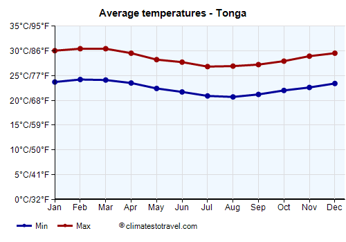
Climate:
The climate of Tonga can vary between islands. However, Tonga as a whole has a tropical, trade‑wind‑driven climate with a hot, wet season from December to April and a cooler, relatively drier season from June to October. Even during the dry season there are still brief showers and thunderstorms. Additional information can be found here:
https://weatherspark.com/y/150281/Average-Weather-in-Tonga-Year-Round
Sources:
“Average Weather in Tonga Year‑Round.” WeatherSpark, weatherspark.com/y/150281/Average-Weather-in-Tonga-Year-Round.
Food and Agriculture Organization of the United Nations. FRA Working Paper 51: Data Collection for the Pacific Region – Tonga. FAO, 2005, www.fao.org/3/ae578e/ae578e.pdf
Food and Agriculture Organization of the United Nations. Global Forest Resources Assessment 2020: Tonga Country Report. FAO, 2020, www.fao.org/forest-resources-assessment
Food and Agriculture Organization of the United Nations. National Fishery Sector Overview: Tonga. FAO Fisheries and Aquaculture Department, www.fao.org/fishery/en/facp/ton
Food and Agriculture Organization of the United Nations. Strengthening Sustainable Land and Agroecosystem Management in Tonga. FAO, openknowledge.fao.org.
Government of Tonga. Fisheries Management Act 2002. Laws of Tonga.
Government of Tonga. Forestry Act 1961. Laws of Tonga.
Government of Tonga. Land Act 1988. Laws of Tonga.
Government of Tonga. National Environment Management Act 2010. Laws of Tonga.
Government of Tonga. Waste Management Act 2005. Laws of Tonga.
Government of Tonga. Waste Management (Levy Deposit) Regulations 2016. Laws of Tonga.
“Geography of Tonga.” Wikipedia, Wikimedia Foundation, en.wikipedia.org/wiki/Geography_of_Tonga.
Reef Resilience Network. “Coastal Reforestation in Tonga.” The Nature Conservancy, reefresilience.org/restoration/tonga/.
Secretariat of the Pacific Regional Environment Programme (SPREP). Tonga Waste Data Profile 2025. SPREP, 2025, www.sprep.org.
“Tonga Environment Data Portal.” Government of Tonga, tonga-data.sprep.org.
“Tonga–Kermadec Ridge.” Wikipedia, Wikimedia Foundation, en.wikipedia.org/wiki/Tonga%E2%80%93Kermadec_Ridge.
Flag of Tonga