Module 6: Intro to Physical Geology
03/08/2026
Samuel Clifford
Chapter 16: Running Water
16.1
Hydrologic Cycle- “[t]he unending circulation of the earth’s water supply. The cycle is powered by energy from the Sun and is characterized by continuous exchanges of water among the oceans, the atmosphere, and the continents.” (Tarbuck, Lutgens, and Linneman 441)
Evaporation is the process by which liquid becomes a gas. Water evaporates from the ocean or land and becomes a part of the atmosphere. Processes then turn the evaporated water back into liquid as precipitation. Which falls back into the ocean or onto land just to begin the process again.
Some of the water that falls on land soaks into the ground, a process called infiltration. The water seeps in the ground until it reaches a lake, river, or ocean. Sometimes though the rate of precipitation exceeds the ability for the ground to soak up water which leads to runoff. Some water is also absorbed by plants and then released into the atmosphere, which is called transpiration.
16.2
The amount of runoff of water on land is determined by five factors:
1. The duration of the precipitation and it’s intensity
2. The amount of water already contained in the soil
3. The nature of the surface the water is falling on
4. The slope of the surface the water is falling on
5. The extent and also type of vegetation
Runoff begins as sheet flow, a thin, broad layer of water moving downslope. As it concentrates, it forms small channels called rills, which merge into gullies. Gullies join to form streams, and streams eventually combine into rivers.
A drainage basin (or watershed) is the area of land that supplies water to a particular stream. The edges of this basin are marked by a divide, an imaginary boundary that separates one basin from another. In mountainous regions the divide may appear as a sharp ridge, while in flatter landscapes it can be harder to identify. Water within the basin flows downhill toward the outlet, the point where the stream leaves the basin, which is always at a lower elevation than the surrounding area.
There are four main stream patterns:
• Dendritic: A branching, tree‑like pattern that forms where the underlying rock is uniform and offers no structural control.
• Radial: Streams flow outward in all directions from a central high point such as a volcano or dome.
• Rectangular: Streams follow straight lines and right‑angle bends because joints or faults in the bedrock guide the flow.
• Trellis: A pattern of parallel main streams with short, right‑angle tributaries that develops in folded or tilted sedimentary layers.
16.3
Streamflow is shaped by the interplay of velocity, channel shape, gradient, and discharge, all of which determine how water moves through a channel. Velocity varies across the stream: it is typically fastest near the surface and in the center of the channel where friction is lowest, and slowest along the bed and banks where water meets resistance. Gradient, the slope of the stream, strongly influences this speed, with steeper gradients producing faster, more energetic flow. Discharge, the volume of water passing a point per unit time, changes with rainfall, snowmelt, and seasonal patterns, and it directly affects the stream’s ability to erode, transport, and deposit sediment.
16.4
Works of Running Water:
-Erosion is the overall process by which running water removes and transports soil, sediment, and rock fragments from the landscape, gradually wearing down slopes and carving channels.
-Quarrying occurs when fast‑moving runoff or streamflow lifts and removes large blocks of rock from the channel bed or banks, usually by exploiting cracks, joints, or weakened zones.
-Abrasion happens when sediment carried by runoff (sand, gravel, pebbles) scrapes, grinds, and scours the surfaces it moves across, effectively “sandpapering” the channel and intensifying erosion.
-Corrosion is the chemical action of water dissolving minerals in rocks; runoff enriched with acids or dissolved ions can chemically break down rock, especially limestone and other soluble materials.
Streams move weathered rock material in three distinct ways, and the method depends on particle size and weight. Dissolved load consists of minerals carried in solution, invisible because they’re chemically dissolved in the water. Suspended load includes fine particles like silt and clay that remain lifted within the water column, giving many rivers their cloudy appearance. Bed load is made of heavier particles (sand, gravel, and pebbles) that move by sliding, rolling, or bouncing along the streambed.
16.5
Bedrock stream channels are carved directly into solid, resistant rock, so their shape is controlled mostly by the underlying geology rather than by the sediment they carry. Because the channel floor cannot easily shift, these streams tend to be narrow, steep, and stable, with erosion occurring mainly through abrasion and quarrying against the exposed rock. Alluvial stream channels, by contrast, are cut into loose, unconsolidated sediment that the stream can readily pick up, move, and redeposit, allowing the channel to migrate laterally, build bars, and change form over time. Their geometry is therefore highly dynamic, responding quickly to variations in discharge and sediment load, which makes them far more adjustable and variable than bedrock channels.
16.6
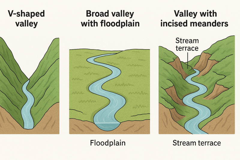
V‑shaped valleys develop in youthful landscapes where streams have abundant energy and actively cut downward into the bedrock, producing steep, narrow profiles with slopes that converge sharply toward the channel. Because vertical erosion dominates over lateral erosion, these valleys retain their characteristic “V” geometry, especially in mountainous or high‑relief terrain.
Broad valleys with floodplains form where a stream has matured and its energy is directed more toward lateral erosion than downward cutting, allowing the channel to meander across a wide, gently sloping floor. Over time, repeated flooding deposits layers of alluvium that build a broad floodplain, creating features such as natural levees, backswamps, and point bars.
Valleys with incised meanders or stream terraces reflect a shift in base level or uplift that causes a once‑meandering stream on a broad floodplain to regain downward‑cutting power, carving its sinuous pattern deep into the landscape. As the stream entrenches, remnants of the former floodplain are left stranded as step‑like stream terraces along the valley walls, preserving evidence of earlier valley levels and past equilibrium conditions.
16.7
Bars, deltas, distributaries, natural levees, back swamps, and alluvial fans are all depositional features created by running water as it loses energy and drops sediment.
Bars form within river channels when flow velocity decreases enough for sand and gravel to accumulate, producing mid‑channel bars, point bars on the inside of meanders, or braided bars in highly sediment‑laden streams. Deltas develop where a river enters a standing body of water, like a lake or ocean, and rapidly deposits sediment, building outward into a triangular or lobate landform. As the delta grows, the main channel splits into distributaries, smaller branching streams that spread water and sediment across the delta plain. Along the channel margins, repeated flooding builds natural levees, low ridges of coarse sediment deposited when floodwaters spill over the banks and immediately lose velocity. Behind these levees, the slower-moving floodwaters drop finer silts and clays, forming poorly drained back swamps that remain wet long after floods recede.
In contrast to these floodplain and deltaic features, alluvial fans form where a high‑gradient stream emerges from a mountain front onto a flat valley floor, causing an abrupt drop in velocity and a fan‑shaped deposit of gravel, sand, and silt. While bars and levees reflect processes within or immediately beside active channels, alluvial fans represent a sudden transition from confined to unconfined flow, allowing sediment to spread widely. Together, these features illustrate how rivers continually adjust to changes in slope, discharge, and sediment load, shaping landscapes through both erosion and deposition. They also show how water’s energy determines the size and location of sediment deposits, from coarse gravels on fans and levees to fine muds in back swamps and delta plains, creating the diverse environments that characterize fluvial systems.
16.8
Floods occur when stream discharge exceeds channel capacity, and their behavior is shaped by both natural processes and human alterations to the landscape. Major flood types include rapid‑onset flash floods, seasonal regional floods, and floods caused by blockages or structural failures. Their severity is influenced by precipitation patterns, snowmelt, surface conditions, and topography. Human activities such as urbanization, deforestation, and construction of levees, dams, and other structures can intensify flooding by altering runoff, reducing infiltration, or creating points of catastrophic failure. Understanding flood frequency and recurrence intervals is essential for assessing long‑term risk and planning development on floodplains.
Flood‑control strategies fall into two broad categories: structural and nonstructural. Structural approaches, such as artificial levees, flood‑control dams, and channelization, aim to confine, redirect, or accelerate water flow, but they are costly and can create a false sense of security. Nonstructural approaches focus on managing land use within floodplains through zoning, hazard mapping, and allowing rivers to maintain natural equilibrium with their floodplain systems. Together, these strategies reflect the balance between engineering solutions and sustainable floodplain management needed to reduce long‑term flood hazards.